Vertical take-off and landing fixed-wing UAV maritime inspection solution Leave a comment
In recent years, my country’s maritime supervision has been facing increasingly diversified situations and more and more important tasks. Only relying on original equipment such as maritime cruise ships cannot meet the needs of the integration of “air, sea and ground” in maritime supervision and rescue. New equipment and methods to strengthen the surveillance and effective control of the waters under its jurisdiction. In order to adapt to the changes in the complexity and diversity of current marine affairs, improve maritime supervision and rescue capabilities, the application of drone technology to maritime inspections can provide new developments for the maritime sector to achieve the three integrated cruise goals of “air, sea, and ground” Ideas and more options.
background
my country is a major maritime and shipping country, and a Class A member of the International Maritime Organization. It has the responsibility and obligation to provide a good navigation environment for ships and protect my country’s marine environment. However, in recent years, the situation faced by my country’s maritime supervision has become increasingly diversified, and the tasks have become more and more important. Only relying on the original equipment such as maritime cruisers can no longer meet the needs of the integration of “air, sea and ground” in maritime supervision and rescue. New equipment and methods are needed to strengthen the surveillance and effective control of the waters under its jurisdiction. Among the many advanced equipment, how to develop ships and aircrafts has become an important topic before us, and the emergence of drones has given us more choices.
Existing maritime cruise supervision model
At present, most of the navigable waters in my country adopt the mode of patrol boats and monitoring systems such as VTS, AIS, CCTV, etc. for cruise supervision. There are also some shortcomings:
1. The patrol ship has a short visual range and slow response when patrolling, and it is difficult to grasp the overall situation. It is impossible to track illegal ships continuously, and it is impossible to obtain evidence and deal with some violations;
2. VTS works in the form of radar waves and has the ability to supervise large ships, but its ability to monitor and supervise small ships is limited, and it is difficult to involve ports, wharves and other sites, and the information obtained is not intuitive, so VTS also has certain limitations;
- The AIS system is a new system that automatically broadcasts the precise location data and ship navigation data provided by GPS through VHF. However, AIS is currently not installed on ships under 300 gross tonnage, but small ships are the source of frequent accidents. AIS There is still a certain blind spot; CCTV can only be used for surveillance in fixed-point areas, and its extension is not enough. The above methods weaken the ability of maritime management to a certain extent.
UAV concept and system composition
Unmanned aerial vehicle (UAV) is an unmanned aerial vehicle controlled by radio equipment or by program. Specifically, it is powered by power, capable of flying remotely and/or autonomously via radio ground, and can be used repeatedly. The difference between it and manned aircraft is firstly unmanned. The flight process is automatically controlled by electronic equipment. There is no need to install any pilot-related equipment on the aircraft. It can effectively save and use space to load application equipment to complete various tasks assigned to it. .
UAV systems mainly include aircraft bodies, flight control systems, data link systems, launch and recovery systems, and mission equipment. The flight control system is also called the flight management and control system, which is equivalent to the “heart” part of the UAV system. It has an important impact on the stability of the UAV, the reliability of data transmission, accuracy, and real-time performance. Its flight performance plays a decisive role. The data link system can ensure the accurate transmission of remote control commands, as well as the real-time and reliability of the UAV receiving and sending information, so as to ensure the timely effectiveness of information feedback and the smooth and accurate completion of tasks. The launch and recovery system ensures that the UAV can fly smoothly to reach a safe altitude and speed, and fall back safely from the sky to the ground after completing the mission. Mission equipment is the equipment carried by the drone when it performs the corresponding mission. The biggest difference between a drone and a manned aircraft is that it cannot complete any task by relying solely on the drone itself. It requires a set of rigorous control systems and application equipment based on the mission. Therefore, the drone has become unmanned.机系统。 Machine system.
Drones can be applied to the business areas of maritime supervision
As an unmanned aerial vehicle controlled by radio remote control equipment or its own program control device, UAV has gradually matured in technology and has been widely used in military and civilian fields. Due to its flexible maneuverability, high timeliness, low cost, low loss, low risk, strong monitoring capabilities and wide coverage, UAVs are very suitable for maritime safety supervision services.
UAVs can be used in maritime patrol law enforcement, investigation and evidence collection and emergency response, maritime search and rescue, marine vessel oil spills, pollution discharge monitoring, navigation mark inspections, waterway surveys and other maritime regulatory business fields. - Maritime patrol law enforcement, investigation and evidence collection and emergency response
At present, the trend of large-scale and rapid marine ships is very obvious. The speed of high-speed ships and large container ships has exceeded 28km, but most of the existing patrol ships in the maritime system cannot reach this speed. At the same time, limited by the objective conditions of patrol boats, the use of patrol boats to carry out cruises has short visual range and slow response, and it is difficult to grasp the overall situation. The illegal ships cannot be tracked continuously and effectively, and some violations cannot be continued to collect evidence and deal with problems. The high-speed and high-efficiency advantages of UAVs can effectively make up for the lack of speed of law enforcement ships. Especially in the field of investigation and evidence collection and emergency response, the use of drones can ensure the speed of response and the timeliness of the investigation, prevent the escape of the ship that caused the accident, and use the onboard camera and photography equipment to record and save evidence to facilitate investigations deal with. - Search and rescue at sea
Generally, sea rescues often use airplanes or drones to quickly reach the scene and fly at low speeds over the target area to search. The live target can be detected by the airborne optically cooled infrared pod, avoiding the omission caused by the uncertainty of manual search and rescue. The refrigerated infrared sensor of the photoelectric pod can distinguish the color of the sound target and the object without temperature in the field of view. The ground station staff can identify the target for the rescue helicopter and ship, and command the rescue helicopter, rescue ship and past ships to coordinate Implement rescue. In addition, drones can reach dangerous areas that many people and ships cannot reach, and can transmit high-definition video and photos to the monitoring center in real time, providing information guarantee for the rapid processing of relevant departments, and using drones to greatly improve rescue efficiency. - Surveillance and emergency operations for oil spill and pollution discharge from ships at sea
Marine environmental protection is one of the most concerned topics of marine countries today. With the increase in marine oil transportation year by year, oil tankers tend to be larger, and the risk of oil spills from marine vessels is also increasing. Statistics show that oil is the largest source of pollution in the ocean, and 42% of the oil discharged into the sea every year is caused by oil transportation. To this end, various maritime countries have formulated oil spill contingency plans, and the International Maritime Organization has also passed resolutions in response. With the increase in China’s oil imports and the continuous increase in offshore oil exploitation, real-time monitoring of fish and ocean oil spills is particularly important. The first few hours after the oil spill at sea is the best time to prevent the spread of pollution and its harm. UAVs are used to monitor important routes and important sea areas for oil extraction in real time. In the event of a crude oil spill, use airborne multispectral imaging. The radar patrols the sea surface, and the dedicated multi-spectral imaging radar can also monitor oil spills at night. At the same time, for the gradually concealed night sewage operation behavior, the multi-spectral imaging radar carried by the drone can determine the pollution behavior through information such as the temperature and color value of the illegal sewage ship and the discharge object. - Inspection of navigation aids
Navigation beacons are the main means of navigational protection. There are many important lighthouses and light poles located on isolated islands along the coast of China. There are many points, long lines, scattered, inconvenient transportation, and very difficult to supply and maintain. Utilizing the mission equipment on the unmanned aircraft to realize the rapid inspection of the navigation mark, timely and effectively report the working status of the navigation mark, and avoid the purposeless inspection, which can effectively improve the normal rate of the navigation mark. - The method of using aerial photography to shoot the ground and water surface to obtain image information, processing, processing and analysis to extract the spatial position and related information of the measured object has been widely used, especially the application of all-digital photogrammetry methods. Aerial photography by drones can also fully meet the requirements of aerial surveys.
Advantages of using drones for maritime inspections - Low purchase cost
The procurement cost of unmanned fixed-wing aircraft is lower than that of manned patrol aircraft and much lower than that of large patrol ships. UAVs, equipped with certain airborne mission equipment, can perform all kinds of supervision and rescue missions with excellent cost performance. - Compared with the captain of a maritime patrol ship, the cost of training a patrol pilot is higher. Flying at sea requires pilots to have considerable experience and have the ability to control at night and in bad weather. The drone does not need to be operated by experienced pilots. After a period of operational technical training, ordinary personnel can control the flight path and speed of the aircraft through the measurement and control vehicle or ship measurement and control device, and the training cost is very low.
- Low unit cruise cost
Compared with manned patrol aircraft, drones are small in size, light in weight, and very economical in fuel consumption. The unmanned helicopter takes off without any auxiliary devices, and the unit cost is lower. Large-scale patrol ships are large in size and weight, and although they consume less fuel per unit weight, the cost based on cruising mileage is much higher than that of UAVs. - Low ground support requirements
Large-scale patrol ships need to build high-grade berths, and daily maintenance generally requires at least 10 professionals. Manned patrol aircraft need to build a large hangar to facilitate daily maintenance work. Fixed-wing aircraft also need to build professional airports, equipped with special landing navigation equipment and runways that meet certain landing grade requirements, and maintenance personnel must also receive response time maintenance training to ensure safe flight of the aircraft. The UAV can take off in a small space, and there is no need to build a dedicated dock or hangar for parking and daily maintenance. Daily maintenance personnel only need 3 people, and the later use cost is low. - No personnel safety risks Although the design and construction of ships and manned aircraft have a high safety factor, under severe weather conditions, small probability events such as damage and crashes may occur. When the UAV performs its mission, it only needs to carry the relevant mission equipment. Even if it encounters bad weather, it cannot be recovered in an accident at most. There is no personnel safety risk issue, so the risk cost is low.
- Fast and efficient, high work efficiency
Most of the ship activities are the Yangtze River channel and are relatively scattered. Traditional boats are used for patrols, with low speed, small field of view, long patrol intervals, and are greatly restricted by natural conditions. They can only be managed linearly and covered in strips. Using unmanned aircraft and airborne mission equipment, the speed of unmanned aerial vehicles is at least 3 to 10 times that of patrol ships. With the advantages of high overhead position and wide equipment monitoring field of view, the scope of supervision is expanded relative to ships. - From the static supervision of maritime affairs to a supervision mode that combines dynamic and static
Air cruising has the advantage of “stand high and see far” and is easy to grasp the overall situation. It has unparalleled advantages in terms of ship dynamic management, pollution prevention monitoring, and ship density control. It should gradually become a maritime on-site monitoring and control system. An important means of rescue command. - Realize emergency search and rescue of accidents and disasters
By loading special search and rescue equipment, the UAV can quickly search and rescue ships and personnel on the surface of the accident and disaster scene, and the scene pictures can be transmitted back to the command center in real time.
The application situation of domestic drone maritime supervision
At present, Tianjin Maritime Safety Administration, Guangdong Maritime Safety Administration, and Yangtze River Maritime Safety Administration have successively carried out a number of unmanned aerial vehicle maritime applications and aerial cruise monitoring attempts, and the country has also used unmanned aerial vehicles to participate in marine oil spill monitoring. Application examples show that the effective combination of maritime systems with drones and patrol ships, VTS, AIS, LRIT and other supervision systems can promote the construction of a safety supervision system featuring “all-round coverage, all-weather operation, and full-process monitoring”, and comprehensively improve The ability and level of maritime administration in accordance with the law and public service.
Issues related to the application of drones to maritime supervision
- Fast and efficient, high work efficiency
- Restricted opening of low-altitude airspace
Out of the needs of national security and homeland air defense, my country puts airspace under military management and implements very strict airspace control. Only part of the airspace and air routes are managed by civil aviation. my country’s “General Aviation Flight Control Regulations”, “Basic Flight Rules” and “Civil UAV Air Traffic Management Measures” all have certain restrictions on the opening of low-altitude airspace. It is understood that the country may relax the management of low-altitude airspace in the next few years, but most of the busy seaports in my country are also economically developed areas, with more civilian and military airports and busy airspace. Therefore, before purchasing drones , Should first coordinate to solve the air traffic control problem in the UAV use area. - The marine environment is complex
Compared with the terrestrial environment, the environment of high humidity and high salinity at sea is corrosive to the drone body to a certain extent, and it must be solved through related technologies before procurement. In addition, the sea is relatively windy, and when drones take off and land in windy weather exceeding level 7, the safety factor will be greatly affected, and the safe use of drones will face greater challenges. - Relatively insufficient stability
Although UAV technology has made great progress, the marine environment is complex and the weather is changeable, and there is a large interference to radio and GPS navigation signals. Maintaining the stability and accuracy of signal transmission will be an important issue for UAVs to be solved urgently. Even in the United States, which has the most advanced drone technology, its drone accident rate exceeds that of manned aircraft, which shows that the stability and security of drone use are relatively insufficient.
Although UAVs have some shortcomings compared with manned aircrafts, their higher economy and excellent performance make them more and more widely recognized and developed in the military and civilian fields. With the continuous advancement of drone technology and the gradual liberalization of low-altitude airspace management, the feasibility and benefits of drones used in maritime supervision and rescue will be greatly improved, and the three integrated cruises of “air, sea and ground” will be realized for my country’s maritime sector. Goals bring new ideas.
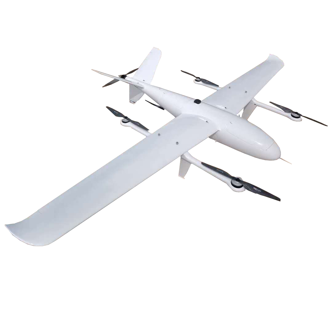
FDG250 electric fixed-wing drone
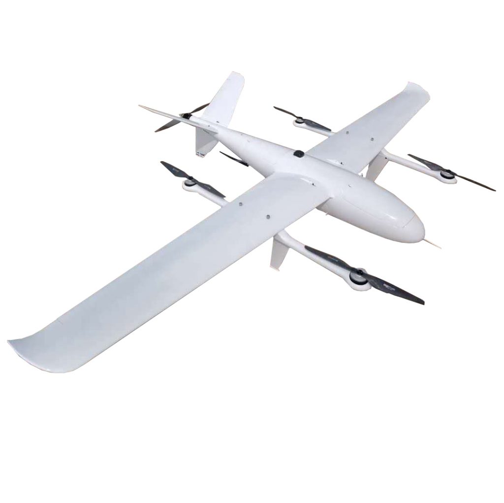
- FDG250 product picture (appearance color is optional)
- FDG250 electric hoisting parameters
Body material: carbon fiber, glass fiber, Kevlar, pvc interlayer, etc.
Body length: 1.26m
Wingspan: 2.5m
Landing gear height: 19.5cm
Landing gear installation position: below the rotor rod
Task bin size: 260mm172mm90mm
Battery compartment size: 260mm150mm85mm (can hold 25300mah and 132000mah at the same time)
Mission compartment position: directly below the center of gravity of the aircraft
Structure weight: about 3.2kg
Maximum take-off weight: less than 13kg
Maximum payload: 2kg (standard load: 1-1.5kg)
Endurance time: 195min/1kg (standard power configuration)
Maximum control distance: manual control by remote control/1km, ground station/standard 30km (up to 80km with numerical control)
Standard cruising speed: 65km/h (about 18m/s)
Maximum cruising speed: 108km/h (30m/s)
Stall speed: 16m/s
Minimum circling radius: 150m
Maximum horizontal lift limit: 4000m above sea level
Wind resistance in fixed-wing mode: no less than 7 wind (17.1m/s)
Maximum wind resistance in rotor take-off and landing mode: no less than class 4 wind (7.9m/s)
Operating environment: -20℃~45℃; can fly in light rain
Power battery: 25300mah (vertical take-off and landing) 132000mah (fixed wing cruise)
Rotor emergency operation time: not less than 6.5min
Take-off and landing method: vertical take-off and landing
Vertical power blade size: 16 inches
Fixed wing tail thruster blade: 14~16 inches
Waterproof rating: IP67 (special customization)
Automatically start floating protection when encountering water (special customization)
Three, FDG250 performance characteristics
The FDG250 UAV platform is an electric long-endurance composite wing vertical take-off and landing UAV independently developed by our company. It uses a fixed-wing combined with a four-rotor composite wing overall layout to solve the problem of fixed-wing UAV vertical take-off in a simple and reliable way. The problem of landing, combined with the characteristics of fixed-wing UAV’s long flight time, high speed and long distance, and the function of vertical take-off and landing of rotary-wing UAV, the vertical take-off and landing mode greatly enhances the environmental adaptability of the modified UAV platform. UAV platforms can operate smoothly in areas with complex terrain and dense buildings such as mountains, hills, jungles, etc., which greatly expands the scope of UAV applications and is an ideal choice for industrial UAVs.
The FDG250 UAV platform is equipped with an industrial-grade vertical take-off and landing fixed-wing flight control and navigation system, as well as professional aerial photography, aerial survey and inspection ground station software, which can ensure that the UAV can fly autonomously throughout the entire process without operator intervention to complete autonomous take-off and flight status During the flight phases such as transition, autonomous cruise, and autonomous landing, it also supports automatic route planning for 1,000 waypoints and an emergency alternate landing plan for 100 waypoints.
The FDG250 UAV platform integrated navigation system (GPS/INS) can realize one-key automatic take-off, landing, hovering, hovering, returning home, altitude setting, parachute opening and various forms of autonomous cruise according to scheduled routes. Provides complete navigation information such as three-dimensional position, three-axis attitude, three-axis speed, three-axis acceleration; internal integration of three-redundancy inertial devices, the main redundancy is ADI high-quality gyroscope and accelerometer, and can switch the spare redundancy according to the working status in real time It has the dual advantages of high measurement accuracy and high reliability.
The FDG250 UAV platform can switch the flight mode by RC remote control, or it can switch automatically; the flight control modes are divided into: manual (remote control by RC remote control), semi-autonomous (remote control of attitude and throttle lever by RC remote control), Fully autonomous (flight according to the scheduled route); realize one-key takeoff, landing, hovering, hovering, height fixation, parachute opening and other functions, which is convenient for users to use; when the fixed wing turns, the elevator feedforward compensation to avoid the flight height decline; multi-rotor When hovering, the nose direction is automatically maintained (the heading angle can also be changed by remote control), and the nose is automatically kept consistent with the route direction when flying on a route; complete flight status monitoring and automatic flight protection functions.
The FDG250 UAV platform provides 8 user routes, and each route can add 800 waypoints; you can choose to automatically switch the mission route after take-off is completed; automatically generate circling routes, circling points, circling radius, and circling circles can be set; automatically generated The return route can also be programmed by the user, and the user will return automatically after the route is completed; the longitude, latitude, altitude, speed, and task of the flight segment can be programmed; the height control of the flight segment can be selected as normal, slope, first hovering and descending, and reaching point Circling up and down, etc.; after reaching the waypoint of the route, you can set to automatically switch to circling, returning or landing; provide parachute opening and camera shutter control to reach the waypoint; provide fixed-distance photographing tasks in the flight segment.
The FDG250 UAV platform has protection modes under various conditions: low voltage, low fuel, low speed protection; abnormal attitude protection; high abnormality protection; low GPS positioning accuracy protection; integrated navigation system failure protection; exceeding maximum control radius protection ;Exceeding the route safety fence protection; communication interruption timeout protection; 100 emergency landing points can be preset, in case of emergency protection, it will automatically land nearby; protection measures include automatic return, automatic landing, parachute opening, etc.
The FDG250 UAV platform is compatible with commonly used Sbus interface RC remote controllers and receivers; manual/autonomous control mode switching can be performed through the RC remote controller; fixed-wing and multi-rotor modal switching can be performed through the RC remote controller; FailSafe (Fail-Safe) status monitoring; RC remote control can be used to register each rudder surface; RC remote control can be used to unlock operation to prevent motor malfunction;
FDG250 UAV platform flight information and mission information are recorded and downloaded separately; the recording frequency and download frequency can be selected from 1Hz~10Hz; the flight information recording time is up to 9 hours; the mission information can be recorded up to 10,000 pieces (POS information of the location of the photo) , Can be renewed for multiple sorties;
The UAV platform has the following characteristics and advantages:
1. Practical and efficient: fixed-wing UAV has the characteristics of long flight time, fast speed, long distance and large load;
2. Vertical take-off and landing: It has the take-off and landing method of rotary wing drones, which greatly reduces the requirements for take-off and landing sites and airspace;
3. Low cost of use: no need for complex and heavy launch and recovery equipment, no need to add additional recovery sensors;
4. Simple operation: integrated special flight control and navigation system, full autonomous flight throughout the whole process, the operator only needs to send the flight plan without professional training and operating experience;
5. Compact system: no complicated auxiliary equipment is required, and transportation, deployment, maintenance, and withdrawal are simple.