DG4Pros combined with M3D, detailed 1:500 cadastre exempt image control practice Leave a comment
The image-free control technology is moving towards maturity, gradually moving from theory to practical application. In this issue, we discuss in detail the feasibility and specific project flow of the DG4 Pros camera in conjunction with the ChengDu flydragon aviation tech co., ltd.’s Mirauge 3D software in 1:500 cadastral precision image-free operation.

UAV aerial photogrammetry is a real-time measurement method with high resolution, high maneuverability, low cost, and limited climatic conditions. However, its image demand is several times that of traditional aerial photogrammetry, and it will also increase by multiples Field measurement workload. Using GPS-assisted aerial triangulation, using carrier phase difference technology to obtain station coordinates, and introducing regional network adjustments as additional observations can greatly reduce field measurement costs and improve work efficiency.
The traditional GPS-assisted AirSat often uses low-precision GPS data, so it can only play an auxiliary role, narrowing the search range of the truth value in the process of finding the truth value of the software. The RTK assisted AT essentially essentially locks the image The true value of the line element is within an extremely small range, so the amount of change is reduced, the accuracy is greatly increased, the dependence on external control information is reduced, and true image-free control can be achieved.
The image-free control technology can not only shorten the aerial survey duration, shorten the duration from months to days, and make the production duration become controllable. The reduction of field work is no longer a matter of “eat by the sky”. At the same time, it can also reduce the operation of internal industry puncture points and improve production efficiency.
The following takes a university in Chengdu, Sichuan Province as an example to introduce the implementation process of image-free control technology. By comparing the difference between the 3D coordinates of the image-free and less control point inspection points and the observation of the image of the house point, the three-dimensional intersection of the intersection and the tilt model house The difference between the three-dimensional coordinates of the point measurement and the actual three-dimensional coordinates of the house point verifies the application accuracy of the image-free technology in 1:500 cadastral survey.
Flight parameter design
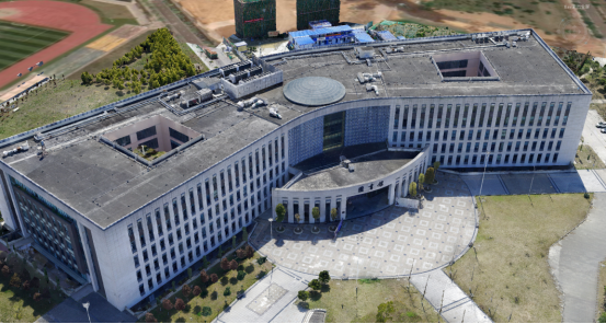
The experimental site is located in a university in Chengdu, Sichuan Province, with a total area of 0.25km². The terrain is relatively flat, mostly low-rise buildings of 4-6 meters, and the highest building is about 25 meters high.
21 routes are laid out in the east-west direction, with a heading overlap of 80% and a lateral overlap of 70%. The unmanned aerial vehicle has an altitude of 100 meters relative to the ground and a ground sampling interval (GSD) of 1.4 cm. A total of 3130 images were acquired. The images were clearly exposed and uniform, meeting the requirements of this experiment.
Equipment selection
On the day of the experiment, the DJI M600 Pro unmanned aerial vehicle was equipped with a Riy-DG4 Pros tilt camera to perform aerial photography operations during the time period when the light was strong and the wind was suitable for flying. 18 ground checkpoints (actually only 14 are used) and 15 house checkpoints of Haixingda ATS320 total station are deployed in the venue using Zhonghaida V90 RTK.

Introduction to 3D modeling software
Mirauge 3D is a domestic and self-developed two-to-three-dimensional integrated image intelligent modeling system, with powerful air and three-solving capabilities, which can effectively support weak textures, different flight heights, large color differences, narrow bands, and measurement area elevations. Various complex terrain data such as large differences.
At the same time, the aerial photographs with the improved chromatic aberration and distortion obtained by the Ruibo camera can process massive data images, and a single project can process 160,000 images with a stable pass rate
Ground control point layout and measurement
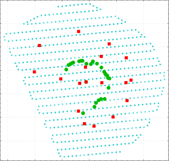
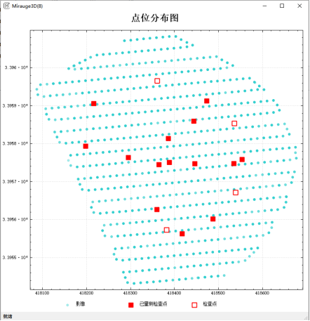
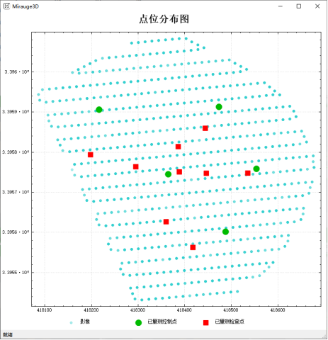
As shown in the figure, 18 ground checkpoints (red for ground checkpoints, green for house checkpoints, and only 14 ground checkpoints are actually used) are arranged in the survey area. The checkpoints are all arranged at obvious corners The three-dimensional coordinates of the ground inspection point are measured by Zhonghaida V90 RTK equipment, and the three-dimensional coordinates of the house inspection point are measured by Haixingda ATS320 total station equipment.
Image-free GNSS-assisted aerial triangulation
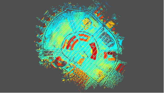
The total number of effective aerial photos obtained in this project is 3135 (redundant aerial photos have been eliminated using Sky-filter). The single node Mirauge 3D is used for free cyberspace three, which takes 2.5 hours; three nodes are used to generate 3D for the target area. The model took nearly 48 hours. The machine configuration is: memory 64G, graphics card RTX2070, processor i 7.
The result of empty three is shown in Figure 2. In order to achieve the precision requirement of 1:500 image-free control, when adjusting the checkpoint, you should choose to use GPS-assisted adjustment to correct the constant band error and the linear band error. Increase the weight of GPS in the software according to the actual situation of the data, and finally check the adjustment.
Accuracy assessment
In this experiment, all ground points are set as checkpoints, so as to avoid the difference between the three-dimensional coordinates of the checkpoints of the image control and the few control points; Poor, as an index to evaluate the geometric accuracy of the measurement results of the image-free air three measurements. The accuracy comparison table is directly generated by the software.
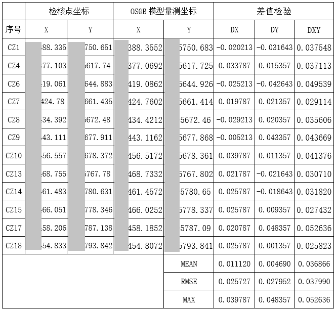
- Free image control accuracy result table
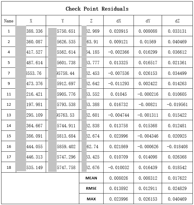
It can be seen from Table 1 that the errors in the plane of the multi-section intersection of the control points are 0.014m, 0.013m, and the elevation is 0.025m respectively, which meets the requirements of the “Code” for the maximum limit of 1:500 scale checkpoint error.
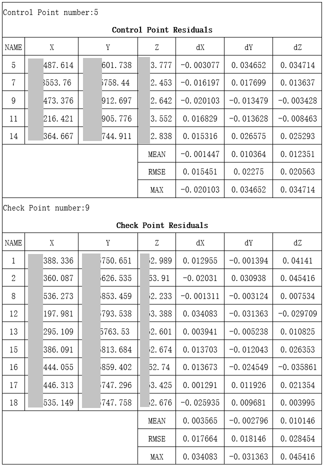
2. Rare control point accuracy result table
The following two tables are the accuracy verification results of the model when using 5 and 9 control points respectively.
3. Accuracy verification of house inspection points
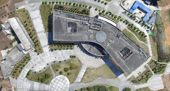
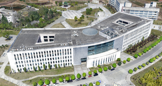
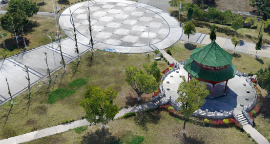
Part of the model effect display
Experimental results
In the case of the combination of DG4 Pros tilt camera, M600 Pro drone and Mirauge 3D, it can fully meet the accuracy requirements of 1:500 cadastral measurement without image control.
To achieve image-free control, in addition to satisfying the high precision POS and reasonable camera distortion parameters of the aerial film, it is also a crucial step to increase the weight of the high-precision GPS in the air-to-air processing section.